
You should spend about 20 minutes on this task. Write at least 150 words.
The maps below show an industrial area in the town of Norbiton, and planned future development of the site.
Summarise the information by selecting and reporting the main features, and make comparisons where relevant.
Summarise the information by selecting and reporting the main features, and make comparisons where relevant.
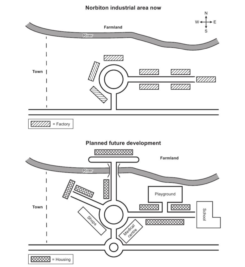
The maps illustrate the current layout of an industrial area in the town of Norbiton and the proposed redevelopment plans for this site in the future.
Overall, it is clear that the area will undergo significant transformation, with the removal of all factories and their replacement with various residential and community facilities. The future development will also introduce new infrastructure to improve connectivity and amenities for local residents.
At present, the area is dominated by a cluster of eight factories situated to the south of a river, which flows from west to east. A single road runs through this industrial zone, with a bridge crossing the river to the east, linking the area to the town centre. There is also a roundabout located on this road to the west, though it currently serves only the factory premises.
In the future, the entire industrial complex will be demolished to make way for a substantial new housing estate. To accommodate the growing population, several new community facilities will be introduced. These include a medical centre, a playground, a school, and a shopping centre, all strategically placed in the southern part of the former industrial site. Additionally, the existing single road will be extended, and two new roundabouts will be constructed, one in the west and another in the east, improving traffic flow and access to the new developments.
Finally, the old bridge over the river will be retained, and a new footbridge will be added to the west, providing pedestrians with direct access to the town and the farmland located on the opposite bank. This will enhance connectivity between the residential area and the surrounding green spaces.
Band Score 5.5The maps illustrates an industrial area in the town of Norbiton, and planned future development of the site. Overall, the area more developed over the period, with several new facilities being added and some excisiting features being replaced. As for the east side of the map, playground and road for playground located in the centre of the map was newly constructed and school also added near the playground. the number of housing declined over the period from five to three. Moreover, Medical centre was constructed in the south of the map. Furthermore, In terms of the west side, although the number of housing located in the centre remaind unchanged, these housing were moved to the north side of the map and the road for these housing was added. Shops on the opposite side of hosuing were constructed and huge housing located in the south side was constructed.
Band Score 5The given diagram depicts the intimation regarding the altertations that will be happened in norbiton industrial area. To begin with, there was a framland in the north side of the river that will be moved to north east side and housing area will be made with the extension of roundabout and a bridge on the the thread . In the south east side all factories will be removed for housing area along will this new playground and school will be constructed. Roundabout will extend to south side and a new small roundabout with road will lay down. Moreover, in between of big and small roundabout in the side of contacted road a medical centre and shops will be established. There will be no change in shouth west in town but in north west side some place will use for homes. Overall, there will a huge difference can be seen nearer to the roundabout of south side. Many new facilities will be provided to residents.
Band Score 6The maps alongside shows the current Norbiton industrial area and planned future development on the site respectively. In the maps we can see a lot of changes in the original area. Upon looking at the map we came to know that most of the area is covered by factories. There is a farmland on the northern side of factories across the river. The town is in the western side from the factories. We can notice that all of the factories are in between the river and the straight road. There exist a junction to get to the factory area. According to the current map there are a total of 8 factories. Now about the second map, here we can see how the Norbiton industrial area will look after the execution of future development plan. The second map shows that all the factories will get replaced with housing. Additionally, there will be a bridge connecting the farmland to the current industrial area. There will be an establishment of school and playground in the eastern side of the area. New roads along with medical shops and other shops will be built. In contrast, the planned future development shows that all the factories will be replaced with housing and other related buildings.
Band Score 5.5This map illustrates a factory area and its coming innovations in Norbiton province. Factories are mainly presents on the surroundings of the circular street, which will be replace by housings areas. On the north of the map, a large river crosses the whole city, and will still remain the same with a bridge that bring roads to the other side of it. Overall, the town will have a dramatical raise of infrastructure, a school, shops, a medical centre and more will be built in this area. Moreover, the remained road is predicted to be highly spread in the province. Provinces will completely disappear to make building areas more predominant in the town. One more circular will be added to the existing road in the south of the map, just below the central circular that will keep its form. Even though, these new renovations in Norbiton city, it will still be not highly urbanised. Indeed, areas like farmland or free spaces will be present.
Band Score 6The maps illustarate changes which are planned to take place in an industrial are in the town of Norbiton from now to the future. Overall, a comparison of two plans reveals dramatic changes from an area for factories to a mainly urban landscape with new facilities. Farmland will be relocated eastwards to make way for the bridge which is expected to be built across the river. To the north of the bridge a large housing is going to made up. All factories are projected to be removed. Six new houses south of the river are going to spring up - three in the west part of the area and three in the west. The shops are planned to be located in the south-west. Right to them medical center is expected to be built. A new school in the east and a playground left to it are projected to be made up.
Band Score 6The maps illustrates changes which are planned to take place in an industrial area in the town of Norbiton from now to future. Overall, a comparisson of two plans reveals dramatic changes from area for factiories to a mainly urban landscape with new facilities. Farmland will be relocated eastwards to make way for the bridge which is expected to be built across the river. To the north of the bridge a large housing is going to be made up. All factories are projected to be removed. Six new housings south to the river are going to spring up - three in the west part of the area and three in the east. The shops are planned to be located in the south-west. Right to them medical center is expected to be built. A new school in the east and a playground left to it are projected to be made up.
Band Score 6The given map shows an outlined plan for the conversion of Norbiton's industrial area to a settlement town for citizens, by the removal of factories and creation of a planned residence instead. The plan especially highlights the bridging of the Northern farmlands beyond the river with the new settlement across town, which should enable convenient transportation and commute across the river. What is also exciting about the new plan may be the modern adaptation of expanding the roadways to a 4-way roundabout, that should ensure less traffic congestion and hassle-free commute. adapting roundabout traffic to ensure no traffic congestion. With the consideration of community facilitations such as school, shops, playground and medical centre, the upcoming residents should have decent living lifestyle and an increased quality of life. The development blueprint is a urbanization plan across the town with the provision of basic community facilitations.
Band Score 6The illustration displays the present and estimated future condition of an industrial area in a town called Norbiton. Overall, the factories are replaced with the housing facilities, shops, playground, medical centre and school in the planned future development. Housing is planned to be the most dominant infrastructure in the town. At present, a farmland and a river are located beside the town in the north. There are total 8 factories where 3 of these are located closely in the middle. However, the remaining 5 factories are located in the eastern part. In contrast, there are no factories in the predicted future development. There are 3 housing infrastructure in northwestern territory and 3 in east side. Moreover, there are plans for building shops and medical centre in the southern part. Furthermore, 1 playground is also expected to build in the future in the north side of the town. Finally, a school is projected to construct in the east.
Band Score 7The map illustrate the current layout of an industrial area in the town of Norbiton and the proposed changes to the site in the future. Overall, the area is planned to undergo significant redevelopment, with the existing factories being replaced by housing and a range of community facilities. The road network will also be considerably expanded, while the farmland and river will remain largely unchanged. At present, the industrial area consists mainly of several factories located around a central roundabout. The roundabout is connected to the main road running from east to west, while the northern part of the site is occupied by farmland, with river running along its southern edge. The town lies to the west of the site. Under the proposed plan, the factories will be removed and replaced by residential accomodation. A new road will extend northwards from the central roundabout, crossing the river and providing acces to a new housing area. Another roundabout will be constructed on the main road to the south, connected to the central roundabout. Several new facilities, including a school, playground, shops and a medical centre, will also be introduced around the residential areas. The farmland and river will remain in place.
Band Score 5.5The graph is an illustration of an area of the town of Norbiton, which will ultimately be replaced by a new development area with various changes. On the north side of this area, close to the river, will be brought under a massive change with a connection by a bridge to the mainland, while the current farmland will remain static. Additionally, there will be a road connection to the centre circle of the premises; a playground will be built near the river in connection with the school road. The school building is to be established on the east side of the area. Besides, a medical centre will also be set up in the south centre, whereas shops will also be built on the south-west side of the city. The factory will be replaced with a residential area, which will bring a significant change in this area. Overall, the current place will undergo a massive change in the near future.
Band Score 6The map illustrates a Norbiton industrial area in the town, and planned future development of the site. Overall, significant number of factories are removed from the place and many apartments are added for housing inhabitants on the planning idea. Several amenities are also constructed over the map. In the future plan, Farmland moved to another place, instead of this, housing place is built and it is converted with the centre of the area. In the range between housing which replaced farmland and the centre, modern bridge is built crossed the river in the northern part of the area. Houses are aslo well-built that are close to the amenities such as playground, medical centre and shops around the map. For people who live there, school is also constructed near the apartments. In the west of the site, some roads and shops are also added.
Band Score 6In the maps is an industrial area in the town of Norbiton shown and the planned future development. The situation now is a town next to factories with one road and roundabout in the middle. In the new plans numerous facilities will be added including a school and a medical centre amongst others while all the factories will be removed. In the current state of the town of Norbiton farmland to the north is seperated by a river without a bridge. While the town and factory part of the town of Norbiton are connected by a road in the south. In total there are now eight factories all next to the road or around the roundabout. After the development the town of Norbiton will be transformed and made more accessible. The farmland will get housing a road and a bridge conecting the new housing block and the farmland to the old industrial area. The old industrial area will be transformed in to a housing community with numerous facilities. The new facilities will be shops and a medical centre around the old roundabout. The old roundabout will now have four roads leading towards it instead of only two like before. The old road to the east will now have a play ground and a school and three seperate housing blocks. The new road to the west will have three housing blocks. On the old road to the south an extra roundabout will be added.
Band Score 5.5The graphics below illustrate an industrial area in the city of Norbiton and its future development plan. This area will go through major changes compared to now, especially in sports facilities and residential areas. In the first map, it is seen that there is farmland which will remain static in the future. But there will be a playground in the middle of this land, just beside the river. Besides, a school will also be built linked to the playground. In the centre of this area, there is nothing except a round circle, but there will be a shop in the future and also a medical centre as well. This centre will be close to the main road.. However, the most remarkable change we will witness is in the place of the factory, because the factory will be replaced with housing. So, this will be a major factor to look at, and it represents the overall vision of this development.
Band Score 6.5The illustration depicts an industrial area in the community of Norbiton, and planned future improvements of the site. Overall, it is evident that the future plan represented additional features and developments all over the site. moreover, these developments comes with changes in the placement and demolitions. In the present, the river on the north side of the area was acting like a barrier between the farmland and the town. meanwhile, in the suggested plan, a bridge that leads over the river to a housing complex is built with the farmland being moved to the northeast side of the area. Furthermore, it is noticeable that its planned for the factories to get removed and replaced with more Housing facilities. looking at the future plan, more children areas is added, such as, a school at the east end of the road and a close by playground. in addition , a small roundabout is added right below the main roundabout, surrounded by a health centre on the east and shopping facilities on the west side.
Band Score 6The map illustrates the current layout of an industrial zone of Norbiton town and the proposed upcoming developments of the same area. Overall, it is abundantly clear that the whole factory premises will be converted into residential properties and public amenities. Additionally, the expansion of the road is expected to be done with the construction of a bridge to make it more accessible for the community. To initiate, the present area consists of a cluster of 8 factories crossing the river to the south. Moreover, there is a roundabout connected to the main road, which provides access to the town. On the other side of the river, there is farmland to the north side. As per the future project, a new bridge will be constructed over the river, which will provide access to new houses built on the north of the river. The factories will be demolished to build residential houses and some community facilities. These amenities include a school, playground, shops, and a medical centre. Furthermore, a new roundabout will be added to the opposite of the previous one to make for convenient access for the residential people.
Band Score 6The maps compare the current layout of an industrial area in the town of Norbiton with the future redevelopment plan. Overall, it can be seen that factories will be replaced with residential neighborhoods, and public amenities will also be built. In addition, new roads will be connected to the existing roundabout, and one more small roundabout will be seen on the south side. At present area site features with central roundabout which linked to a main road that running in the south. Factories surround to the roundabout, with three on the western side and five on the eastern side. In the north side, the area is bordered by a river, beyond which lies a farmland. Under the proposed plan, factories will be replaced by housing properties. The road network will be significantly expanded towards the western side and the north side. The new north road will be crossing the river to serve new housing which will be constructed there. Along with this, a new small roundabout will be added on that will be connected to the existing roundabout and the main road. As for amenities, a playground and school will construct in the eastern side, while shops and a medical center will be seen on the southern side along the new roundabout.
Band Score 5.5The two maps illustrate the layout of an industrial area in the town of Norbiton in the present and the developments planned for the future respectively. There are significant differences between the current layout and the future plan. Overall, the most notable change will be the transformation of factory facilities into houses. Furthermore, the total area will expand by constructing a bridge that links buildings on the other side of the river with the central roundabout. As a result, the current farmland will be positioned in the north-east side of the town. In more details, all of the present factories will be demolished and will be transformed into houses. A new roundabout in the southern point will be linked with the central one. This area will be allocated to shops and a medical centre. Along the main roundabout a large number of houses will be constructed which is The two maps illustrate the outlay of an industrial area in the town of Norbiton in the present and the developments planned for the future respectively. The differences will be highlighted in this essay. Overall, the most notable change will be the transformation of factory facilities into houses. Furthermore, the total area will expand by constructing a bridge that links buildings on the other side of the river with the central roundabout. As a result, the current farmland will be positioned in the north-eastern side of the town. To get in more details, all of the present factories will be demolished and will be transformed into houses. A new roundabout in the southern limit will be linked with the central one. This area will be accounted for shops and a medical centre. Along the main roundabout a large number of houses will be constructed which is The two maps illustrate the outlay of an industrial area in the town of Norbiton in the present and the developments planned for the future respectively. The differences will be highlighted in this essay. Overall, the most notable change will be the transformation of factory facilities into houses. Furthermore, the total area will expand by constructing a bridge that links buildings on the other side of the river with the central roundabout. As a result, the current farmland will be positioned in the north-eastern side of the town. To get in more details, all of the present factories will be demolished and will be transformed into houses. A new roundabout in the southern limit will be linked with the central one. This area will be accounted for shops and a medical centre. Along the main roundabout a large number of houses will be constructed which is The two maps illustrate the outlay of an industrial area in the town of Norbiton in the present and the developments planned for the future respectively. The differences will be highlighted in this essay. Overall, the most notable change will be the transformation of factory facilities into houses. Furthermore, the total area will expand by constructing a bridge that links buildings on the other side of the river with the central roundabout. As a result, the current farmland will be positioned in the north-eastern side of the town. To get in more details, all of the present factories will be demolished and will be transformed into houses. A new roundabout in the southern limit will be linked with the central one. This area will be accounted for shops and a medical centre. Along the main roundabout a large number of houses will be constructed which is The two maps illustrate the outlay of an industrial area in the town of Norbiton in the present and the developments planned for the future respectively. The differences will be highlighted in this essay. Overall, the most notable change will be the transformation of factory facilities into houses. Furthermore, the total area will expand by constructing a bridge that links buildings on the other side of the river with the central roundabout. As a result, the current farmland will be positioned in the north-eastern side of the town. To get in more details, all of the present factories will be demolished and will be transformed into houses. A new roundabout in the southern limit will be linked with the central one. This area will be accounted for shops and a medical centre. Along the main roundabout a large number of houses will be constructed which is currently surrounded by factories. In stark contrast, more facilities will be established such as a playground and a school that currently do not exist.
Band Score 5The maps illustrate the area of Norbitan aspected to become more modern and accessible. Overall, it can be easily seen that a randobout will be developed and axpanded to connected added roads. Furthermore, factories won t be in Norbiton area. If we look at the nourth-west side of the area there will be several changes happend which the roads will be expanded and some residantial buildings are planned to built also, a bridge planned to built which connected to the randabout to houising areas. In addition, a second randabout which connected the firs one and on the nourth-east sides of it a medical cente will planned to built. On the right side o the map there will several haousing areas pllaned to built which located next to the main roads and playground will be added. On the rightest side of a road there will be added a school for children.
Band Score 7The maps show the current layout of an industrial area in Norbiton and its planned future redevelopment. Overall, the site is set to be completely transformed from an industrial estate into a residential neighbourhood, accompanied by various public facilities. All existing factories will be demolished and replaced with housing, while new infrastructure—including roads, shops, a school, a medical centre, and a playground—will be introduced. At present, the area features a central roundabout linked to a single road running south to the main road. Factories are grouped around this roundabout, with three on the western side and five on the eastern side. To the north, the site is bordered by a river, beyond which lies farmland. Under the proposed plan, all factories will be cleared to make way for housing. The road network will be significantly expanded: a new roundabout will be constructed on the southern main road and connected to the existing one. In addition, a new road will run northwards, crossing the river via a bridge, to serve new housing developments on the far side. More residential blocks will also be built on both the eastern and western fringes of the area. As for amenities, a shop is planned for the southwest of the central roundabout, and a medical centre will be situated to the southeast. On the eastern side, a playground and a school will be added, offering future residents recreational and educational facilities.
Band Score 7.5The maps compare the current layout of an industrial estate in the town of Norbiton with a proposed plan for its future redevelopment. Overall, the site is set to undergo a complete transformation from an industrial zone into a predominantly residential neighbourhood. Every existing factory will be removed and replaced by housing, while the transport network will be significantly expanded. In addition, several community facilities, including a school, a medical centre, a shop and a playground, will be introduced to create a self-contained residential area. Although the internal layout will change dramatically, the surrounding farmland and the river will remain largely unchanged. At present, the industrial estate is centred on a single roundabout connected to the main road by one access road extending southwards. Eight factories are distributed around this roundabout, with three located on the western side and five positioned to the east. To the north of the site runs a river, beyond which lies an area of farmland. There are currently no residential buildings, public services or recreational facilities within the industrial estate. Under the proposed redevelopment, all factories will be demolished to make way for several housing developments spread across both sides of the site. The road system will also be modernised considerably. A second roundabout will be constructed on the main road to the south and linked directly to the existing one, improving access throughout the area. Furthermore, a new road will extend northwards from the central roundabout, crossing the river by means of a newly built bridge and providing access to additional housing situated beyond the river. Besides the residential developments, a range of public amenities will be added to support the future community. A shop will be located to the south-west of the central roundabout, while a medical centre will be built on the south-eastern side. On the eastern side of the development, a large playground will be created adjacent to several housing blocks, with a school positioned further to the east. These additions will transform the former industrial estate into a well-equipped residential neighbourhood designed to meet the daily needs of its inhabitants.
Band Score 7The maps illustrate the current layout of an industrial area in the town of Norbiton and the proposed redevelopment of the site in the future. Overall, the industrial estate is planned to undergo a complete transformation into a residential neighbourhood with a range of public facilities. All factories will be removed and replaced by housing, while new roads, shops, a school, a medical centre and a playground will also be added. At present, the site consists of a central roundabout connected to a single road leading south to the main road. Several factories are located around the roundabout, with three on the western side and five on the eastern side. To the north of the industrial area lies a river, beyond which is farmland. Under the proposed plan, every factory will be demolished and replaced with housing. The existing road network will be expanded considerably. A new roundabout will be built on the southern main road, connected to the original roundabout. In addition, a new road will extend northwards, crossing the river via a bridge to provide access to new housing built on the opposite side. Several new residential blocks will also be constructed on both the eastern and western sides of the development. Furthermore, a shop will be built to the southwest of the central roundabout, while a medical centre will be located to the southeast. On the eastern side, a playground and a school will be introduced, providing recreational and educational facilities for future residents.